I have an odd feeling about on this
day. I have planned this hike for a long time but its as if I feel so weak and
my mind was frozen when I woke up on this morning. Being as planned I still go
for it. I woke up, prepared my things and went into the terminal, like I have
no feeling of excitement. Maybe that’s why I never got to travel early. All I
know is that I took a bus and I arrived in bukidnon. It was when that I saw the
mountain while I was riding on a hired motorcycle(habal-habal) that my
excitement leveled up.
Mt. Capistrano is located in Sitio Binalbagan, Barangay Simaya, Malaybalay City. The mountain stands in the middle of a wide plain. Its like a tower in the middle of a football field where you can see a 360 degrees view in its surrounding barangays when you are in the summit.
 |
The drop off point in Sitio
Binalbagan. Just barely before reaching the Elementary School. When you arrive
at the sitio, you can just ask the locals there. The starting point is just
beside the main road.
|
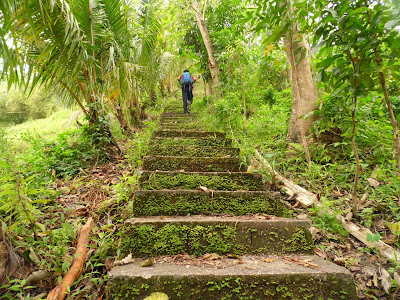
Just a little walk from the drop
point while I was following the trail, I was surprised to see that there is are
concrete stairs. I never expected to see something like this. Not in here.


Just a little walk from the drop
point while I was following the trail, I was surprised to see that there is a
concrete stairway. I never expected to see something like this. Not in here. I
am now on the foot of the mountain.
 | |
| Mt. Musuan on extreme left and Kalatungan range on the right |

After the concrete stairs is where
the true adventure begins. This is what I meant for adventure: where you are
clinging on grass on a steep slope, where you have to secure your foot on a
hole to step in. This is fun. Not with the comfort of concrete stairs.


 |
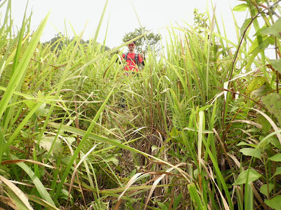
| I have to cling on to the tree to catch my breath. It’s good to see that they have trimmed the cogon grass on the way through otherwise it would be a very spiky pass. |
Oh there it is! .It’s my favorite,
the spiky cogon grass and its getting thicker. I have to wear my arm protection. This is the grass section of the
trail.


Halfway through the summit, I stopped to look at the
landscape as it gets grander and from where I stand I got the chance to see the
main road where I have to magnify (zoom) my camera to look at the vehicles that look like
miniatures.


At the end of the grass section is the start of the rocks and trees section.

 |
| In here, I can use my hands to share the weight in going up by holding on to the fallen trees. |
Going further, the rocks just gets bigger and the vegetation thicker.

The trees and rocks were
interrupted by this section, the small bamboo section. The local term for this
bamboo is called bagakay where
by myth is a good weapon to kill monsters or mythical figures like aswang or
manananggal and the like. This section is like a small pass before reaching the
summit but it is very important.
This section is what I can consider as refuge section because after this section is an all-out rock sections that I suspected where most hikers get lost on the trail. Because the trail is not visible enough and most of the time you have to step on rocks and the only sign of the trail is the smudge of mud on the rocks. There are many reports of hikers getting lost and have to be rescued. During one of my climb I have met some hikers along the trail and they asked me if it is my first time because they have been warned that there are group of climbers who got lost several days before and the locals have to rescue them.

This section is what I can consider as refuge section because after this section is an all-out rock sections that I suspected where most hikers get lost on the trail. Because the trail is not visible enough and most of the time you have to step on rocks and the only sign of the trail is the smudge of mud on the rocks. There are many reports of hikers getting lost and have to be rescued. During one of my climb I have met some hikers along the trail and they asked me if it is my first time because they have been warned that there are group of climbers who got lost several days before and the locals have to rescue them.

.


 |
| A good campsite upon reaching the summit. |
The views from the rocky summit. There are rocks everywhere. In all shapes and
sizes.


The wide plains of rice fields divided into slabs. Rice
production is the prime source of living in the area.


up here in the summit I can see a full view of the things and activities below.
The fishponds surrounded by the cornfields


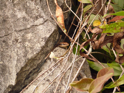
While I was busy taking pictures at
the big rock that I am standing in. there was something rustling in the leaves
that’s getting my attention. I have noticed it when I arrived here but when I
came closer it didn’t bother to go away. It just stayed on my back.Its
like even taking a pose for the camera. So I took the gesture to take the
picture.ha ha.


There are rocks
that form with gaps and holes like these which are very useful shelters.


I saw these daisies in the summit growing among the
rocks. Few flowers like these survive with these kind of environment.


The big platform of rock that’s
been eroded with the combination of extreme heat, rain and air. I can see from
here the 360 degrees view of the landscape below. Kalatungan range can be seen
on the far south.


 | |
| Mt. Musuan as seen from Mt. Capistrano summit |
 | |||||
| Kitanglad range as seen from the summit of Mt. Capistrano |
 | |
| Kalatungan mountain range as seen from Mt. Capistrano |
 |
| the two giants; Kalatungan range(left) and Kitanglad range(right) side by side |
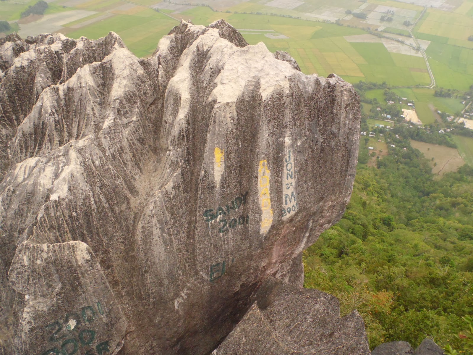 |
| the ever annoying writings |
Roaming around I came upon a campsite and rest for a while


And then I got to see these pile of liquor bottles and
cans on one side left by some previous irresponsible climbers.


The weather this day is good.
It’s gloomy and the sun was hidden by the clouds but no rain just misty. Due to time constraints after taking a rest I decided to go
down.
I’ve had my share, I almost got
lost during the descent. All I was doing during the ascent is following the
trail. The trail then is visible but in going down it’s hard to notice. From
the summit, I somehow got a wrong turn in getting down into the forest.
It is somewhere within this area
here that I took the wrong turn.

I was like going
in a loop and I couldn’t find any more trails. I kept familiarizing the place,
looking for the rocks and trees that might help me recognize. My instinct tells
me that I am not on the right trail. I was going back and forth on the trail
trying to find out where part did I miss. There are times that I go beyond the
trail and went on my own but still it leads me nowhere. All I can see are trees
and rocks. I went back right from the start of the summit and tried to figure
out where I missed. I saw a trail that’s barely visible and followed it with
all the hopes that lead to one of the sections. It led me to the bamboo
section. It was a picture of relief. Its really hard to notice the trail with
all the combination of rocks and trees. It is a risky trade to scramble into
the rocks and trees where I almost decided to do then.
When I arrived at the base I was
very thirsty and my canteen ran out since there is no water station on the
trail.
I asked for water in a nearby
house and the people there are kind enough to extend their hospitality. Then I
rode a motorcycle to ride my way to the town and waited for a bus to take my
way home.
due to the number of hikers getting lost and the locals held responsible for the rescue, i will not recommend it for first timers.
How to get there:
-- Ride a bus from cagayan de oro or davao bound for bukidnon and tell the driver to drop at Aglayan crossing along the highway. Aglayan is a barangay which is part of Malaybalay City. Fare is 115 pesos
--from Aglayan crossing, ride a motorcycle to go to sitio Binalbagan. fare is 25-30 pesos. drop at the Elementary School and just ask the locals there for the entry point, it is just somewhere there.